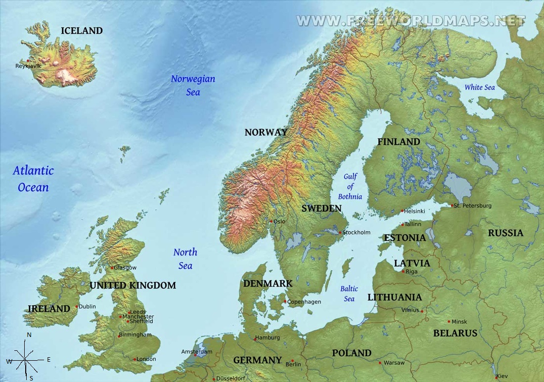
Northern Europe Physical Map
Northern Europe Physical Map
Physical Map Analysis- The physical landscape of Northern Europe is mostly ocean, though there are some highlands in Norway. The oceans and gulfs that are in Northern Europe were used as a faster transportation of people and goods from one country to another because there is less distance over the water than going all the way around the countries. Though the oceans also proved very treacherous because many voyages had not reached the destination and a lot of sailors died because of the separation of countries. The separation of Iceland from the rest of North Europe proves to be disadvantageous because medical supplies and goods took a long time to get there in the past and this caused the death of many people who needed medical supplies. The mountains in Norway have made it hard to cross the land to get to new places and countries.
Physical Map Analysis- The physical landscape of Northern Europe is mostly ocean, though there are some highlands in Norway. The oceans and gulfs that are in Northern Europe were used as a faster transportation of people and goods from one country to another because there is less distance over the water than going all the way around the countries. Though the oceans also proved very treacherous because many voyages had not reached the destination and a lot of sailors died because of the separation of countries. The separation of Iceland from the rest of North Europe proves to be disadvantageous because medical supplies and goods took a long time to get there in the past and this caused the death of many people who needed medical supplies. The mountains in Norway have made it hard to cross the land to get to new places and countries.
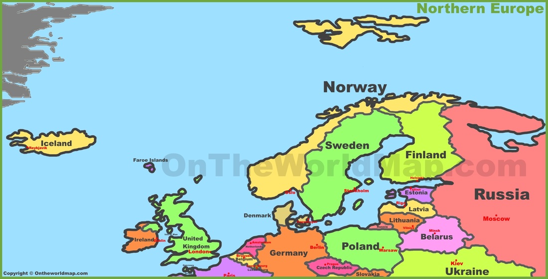
Northern Europe: Political Map
Political Map Analysis- The two maps above are very different in both border location and country names. The present borders are more spaced out and there are more countries than those in the historical map. Also where the United Kingdom was separated into two countries, England and Scotland, also Finland doesn’t exist on the historical. Iceland wasn’t found when this map was made so it is also missing in the historical map. I suspect the borders have changed due to political and social conflicts. These issues may have lead to the creation of new countries and changes in border locations.
Political Map Analysis- The two maps above are very different in both border location and country names. The present borders are more spaced out and there are more countries than those in the historical map. Also where the United Kingdom was separated into two countries, England and Scotland, also Finland doesn’t exist on the historical. Iceland wasn’t found when this map was made so it is also missing in the historical map. I suspect the borders have changed due to political and social conflicts. These issues may have lead to the creation of new countries and changes in border locations.
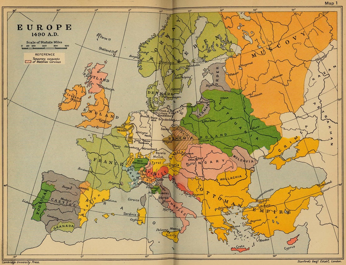
Europe: Historical Map
Major Landforms-
Denmark- Guden River, Odense River, Stora River, Skjern River, Vida River.
Estonia- Narva River, Emajogi River, Suur Munamagi Mountain, Collapse Limestone Plateaus in Northern Estonia.
Finland- Oulu River, Pyhäjoki River, Kalajoki River, Kemijoki River, Torne River.
Iceland- Blanda River, Fnjoska River, Ellioaar River, Olfusa River.
Ireland- Liffey River, Lee River, Swilly River, Lagan River, Barrow River.
Latvia- Musa River, Guaja River, Gaizina Kalns Mountains, Egļukalns, Daugavpils Mountains.
Lithuania- Juozapinė Hill, Neman River, Jura River, Duagava River.
Norway- Glomma River, Gaula River, Namsen River, Galdhøpiggen Mountain.
Sweden- Kalix River, Torne River, Eman River, Kebnekaise Mountain.
United Kingdom and Northern Ireland- Ben Nevis Mountain, Snowdon Mountain, Severn River, Thames River, Trent River.
